Home / CAG Sim
CUAS SIMULATOR AVAILABLE JANUARY 2027

Rehearse the whole drone response, every seat at once, over your own venue.
Built from lessons learned leading a FIFA World Cup 2026 ASOC, before, during and after the matches, and shaped by the local and federal partners who work CUAS at major events.
Why we built it
A full CUAS exercise is hard to stage. This one isn't.
A field exercise means gear in the field, frequency coordination, the right federal authority and a lot of people in one place for one day. Most teams get to do it once a year, if that.
CAG Sim puts every position into the same incident whenever you want to train, with no equipment to deploy and nothing transmitting. It was built by people who ran these operations for real, and it follows the workflow we teach in our GIT + ASOC course.
Five seats, one incident
Each position does its real job.
Exercise setup
Place the venue and TFR rings, load real building heights, site sensors on actual roofs, stage the teams and start drone traffic. Add drones, change the weather and take sensors offline while the exercise runs.
Detection
Tracks arrive with Remote ID, model, speed, altitude and the pilot's home point. Triage the picture and dispatch the closest team.
Detection and mitigation
Practice the mitigation decision: choose a cyber takeover, a fend-off or, as a last resort under procedure, jamming, and see the simulated result. A jam outside procedure is logged as one. Decisions are simulated only and imply no authority to mitigate.
Drone Air Team
Launch overwatch toward the pilot's home point and track the operator from above through a simulated drone camera, with thermal after dark.
Ground Intercept Team
Drive the real street route, arrive on scene and work the contact. Sometimes the operator is there, sometimes they already left, sometimes the drone is already down.
One shared picture
Trainees join the instructor's exercise with a code from their own screens. The first mitigator to engage a drone owns it.
What is modeled
Realistic enough to argue about in the hot wash.
- Sensors and coverage. Remote ID receivers, RF detection, radar and simulated cyber takeover and RF jamming, each with its own range, mounting height and line of sight against real buildings.
- Drone behavior. Hobbyists, inspection flights, out-and-back runs and loiterers, with and without Remote ID. Sub-250 g drones, fiber-optic FPVs and autonomous flights included.
- Mitigation decisions that can fail. Simulated takeovers depend on the link budget and the drone's protocol, so the decision can go wrong.
- Manned traffic. Helicopters and planes show up on radar so crews learn to deconflict, not react.
- Ground response. Closest-team dispatch, street routing, on-scene time and the contact outcome, all logged.
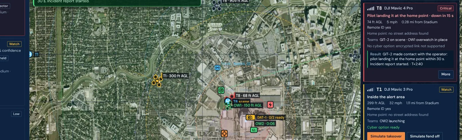
Stadium exercise over real imagery. Drones inside the TFR, teams dispatched, one operator already contacted.
Field teams
Ground and air teams train on their own phones.
GIT and DAT crews open a web link, no app to install. They get the assignment card, a map with directions, one-tap En route, On scene and Clear, drone photos stamped with time and place, and chat with the operations center.
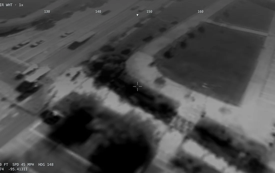
Simulated DAT drone camera in thermal, over real imagery of the exercise area.
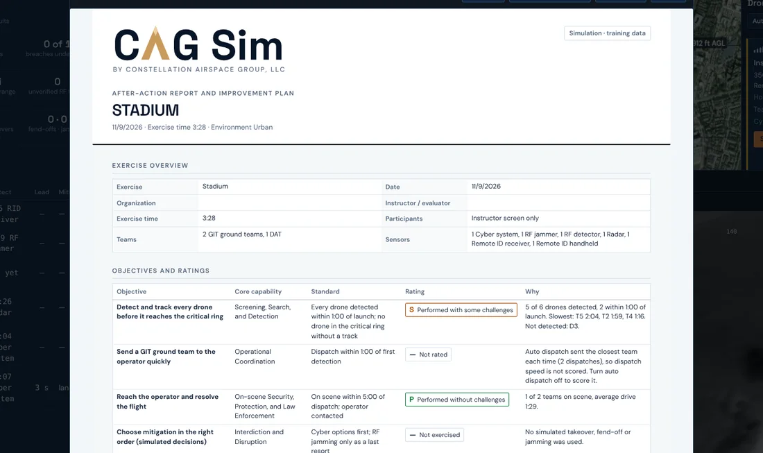
Debrief
The paperwork is done when the exercise ends.
Every GIT contact fills in a UAS incident report. The after-action report builds itself: time to detect, warning time before the critical ring, undetected breaches, takeover results and drive times, drone by drone. Print it or save it as a PDF.
Any site
Same workflow, any airspace.
Events and venues
Build the venue, the TFR and the sensor plan you will actually run, then rehearse before the gates open.
Airports
Traffic patterns built from a year of real Remote ID detections around a major hub airport.
Critical infrastructure
Model coverage around ports, data centers and substations and train the response before something crosses the fence line.
Any U.S. address
Building footprints and heights from FEMA, OpenStreetMap and Microsoft, so line of sight matches the ground.
Training only
Train the decision. Nothing transmits.
Every sensor, jammer and drone is simulated; nothing transmits and nothing flies. Mitigation in CAG Sim is a simulated decision only, so the whole team can practice it without 124n authority or FAA and FCC approvals.
Training does not grant or replace any legal authority to detect or mitigate drones.
CAG Sim is a training and planning tool. Sensor ranges come from field detection data and published specifications, adjusted for the environment; takeover and fend-off outcomes are simplified training models, not manufacturer specifications. Training in the simulator does not grant or replace any legal authority to detect or mitigate drones.
FAQ
Questions we hear.
Do we need 124n authority or FAA / FCC approval to train in CAG Sim?
No. Every sensor, jammer and drone is simulated; nothing transmits and nothing flies. Training does not grant or replace any legal authority to detect or mitigate drones.
What equipment do we need?
A web browser. Field teams use their own phones through a web link, with no app to install.
Can it run on our own network?
Yes. It runs in the cloud or on your own closed network.
Can it model our site and our sensors?
Yes. Place your venue by address or GPS, load real building heights from FEMA, OpenStreetMap and Microsoft, and site your sensors on actual roofs. We build your workspace with you during onboarding.
How realistic are the sensor ranges and takeover results?
Sensor ranges come from field detection data and published specifications, adjusted for the environment. Takeover and fend-off outcomes are simplified training models, not manufacturer specifications. It is built for training and planning, not as a performance guarantee.
How is it priced and when is it available?
Bought directly, an annual license per organization covers your whole team, with onboarding included. For FEMA CUAS grant-funded work, simulator practice is delivered inside training and exercise services with no separate license fee. CAG Sim is available January 2027; demos are running now.
Contact
See CAG Sim run over your own venue.
Tell us the site or event you protect and who would train. We will set up a scenario over your venue and walk your team through it.
Prefer email? justin@cagairspace.com